
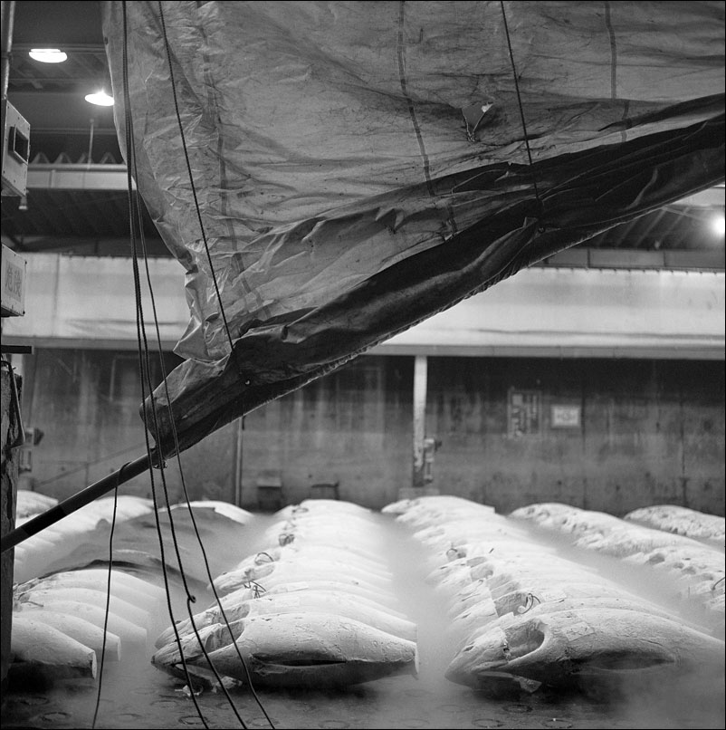
 From September 30th, visitors will not be able to view the fish market. October 6th, 2018 marks the last business day for the Tokyo Central Wholesale Market in Tsukiji: the market will move a few kilometers away to Toyosu. I was fortunate to be able to visit the market at its peak in the early 1990s. I produced a small book on this amazing place: Tsukiji: Tokyo Fish Market Suite. While the market is clearly in many people’s hearts, the aging 1935 structure was in need of updating. I am grateful to have experienced this place. Still, access to the fish market and its famous tuna auctions will not be the same. Click on the image for a larger view.
Category Archives: Tokyo
Fishing
 Click on the image for a larger view.
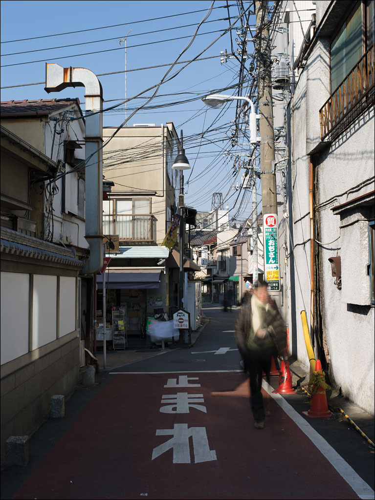
Koenji—On the Streets of Tokyo
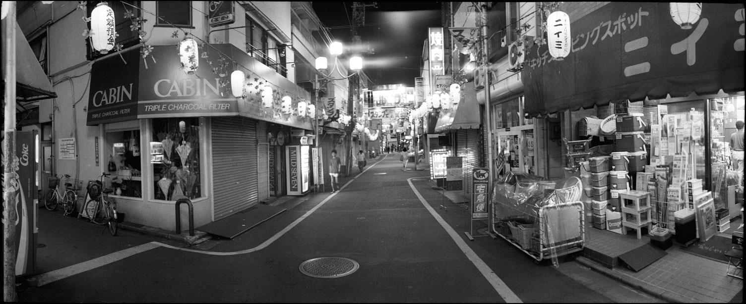 In the 1990s, shopping streets were a common feature of Tokyo neighborhoods and a central locus for communities. Shops were often multigenerational family businesses. Today, large department stores and online retailers are making the economics of running local stores difficult, if not impossible. This street in Koenji from the 90s is typical of many of these thoroughfares. Click on the image for a larger view.
Shinobazu no Ike
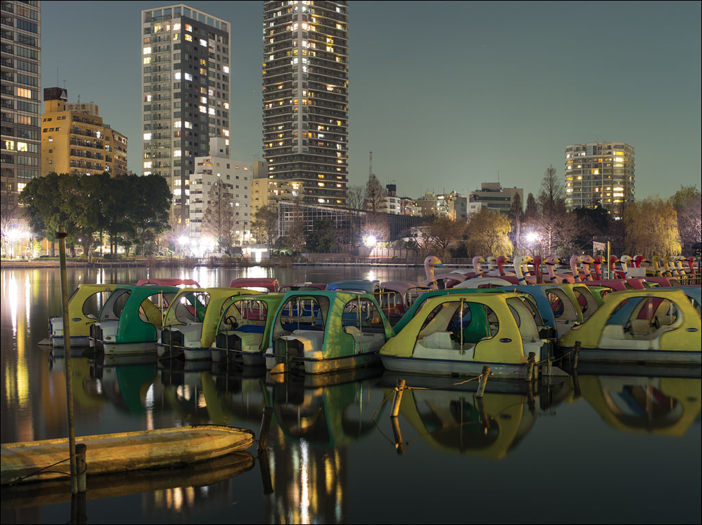 Shinobazu no Ike, or Shinobazu Pond, is located in Ueno Park, Tokyo. This is all that remains of the marsh that has been filled since Edo was established in the seventeenth century. The eastern part of Tokyo was reclaimed from this marsh and is protected by a series of flood walls. During World War II, the pond was used for growing rice. After the war, discussions on whether to convert the area to baseball fields were held. Boating on this pond goes back to 1931. This image is from our book Earth, Water, Fire, Wind, Emptiness: Tokyo Landscapes. Click on the image for a larger view.
Number 3 Daiba
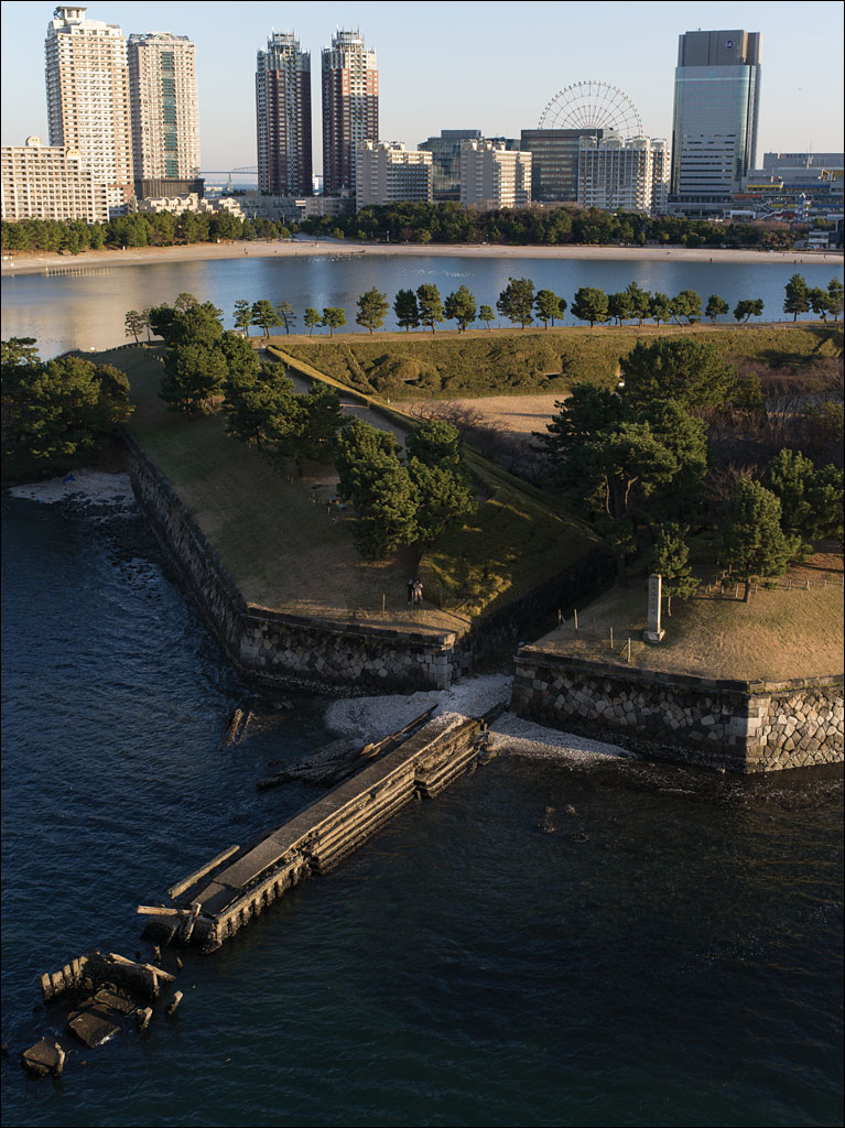 What looks like a peaceful Japanese garden is Number 3 Daiba, a fortification built in 1853 as a response to attempts by US Commodore Perry to open Japan. Beyond that is the artificial island of Odaiba, which was constructed after World War II and one of the planned sites for the 2020 Tokyo Olympic Games. Between the two high-rise apartment building on the left is Tokyo Gate Bridge, the furthest extent of the city into the bay. Number 3 Daiba was originally built several kilometers off the coast of the city in open water. This image comes from our book Earth, Water, Fire, Wind, Emptiness: Tokyo Landscapes. Click on the image for a larger view.
Kasai Rinkai Park
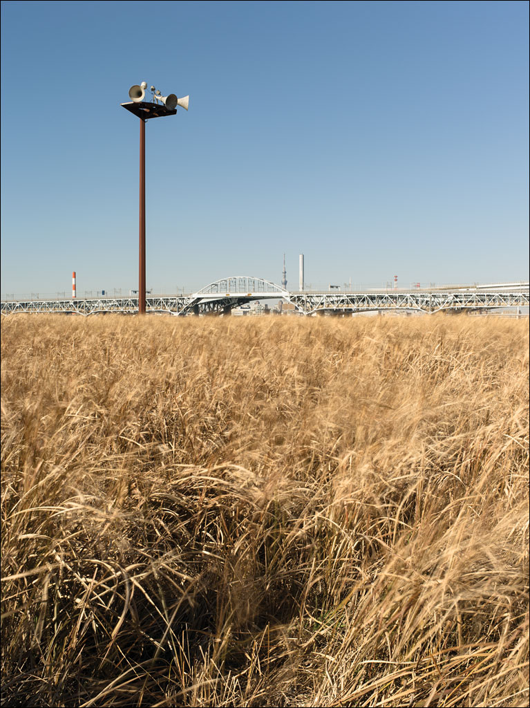 Kasai Rinkai Park is on Tokyo Bay. It is an artificial island built to preserve the natural habitat of Tokyo bay destroyed by development. The bridge in in the background is the main highway that connects Tokyo with Chiba, Tokyo Disneyland, and Narita International Airport. The loudspeakers on the post warn people of approaching tsunamis. This image is from our book Earth, Water, Fire, Wind, Emptiness: Tokyo Landscape. Click on the image for a larger view.
Tokyo Gate Bridge
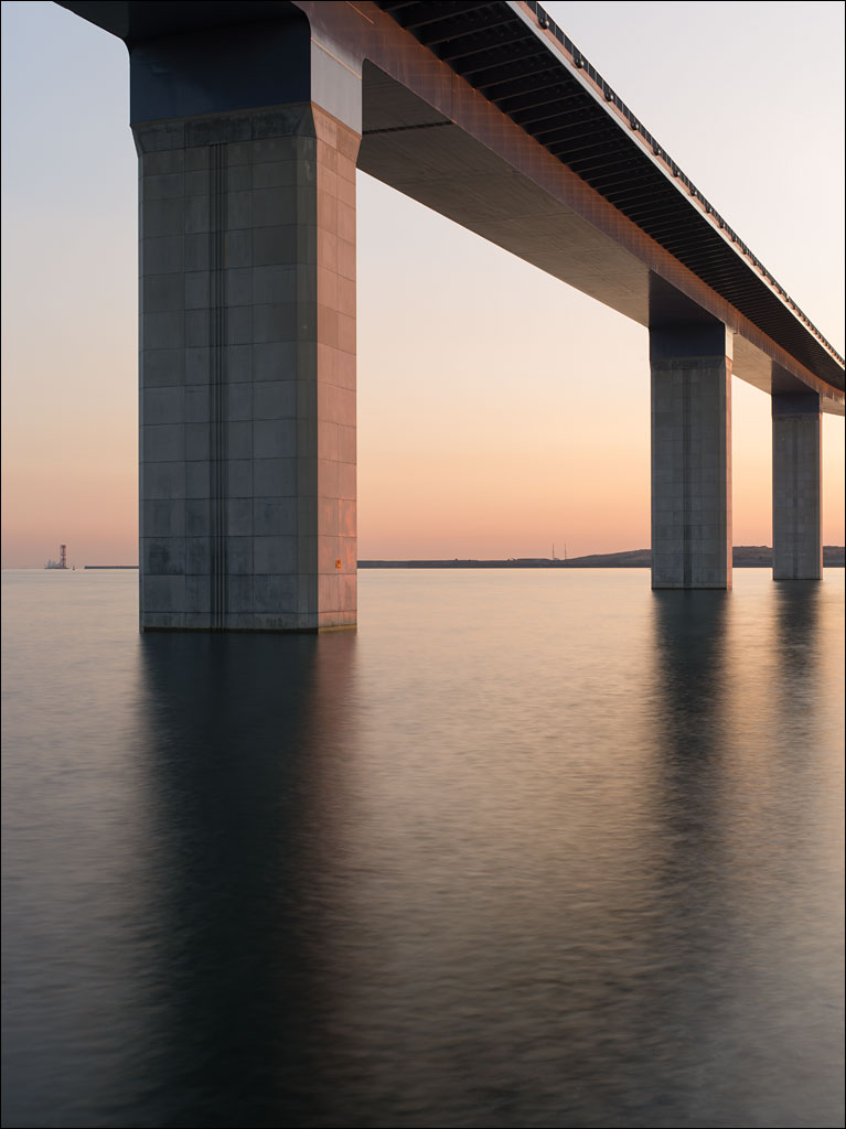 If there was a defined edge to the city of Tokyo, this would be it. Tokyo Gate Bridge is the furthest public highway built out into Tokyo bay. The island on the horizon is Chuo Bohatei, Tokyo’s largest landfill, which is reaching the edge of the municipality’s border. This image is from Earth, Water, Fire, Wind, Emptiness: Tokyo Landscape. The image is also an optical illusion: can you tell if the bridge piers are getting thinner or taller the further away they are? Click on the image for a larger view.
Edogawa
 The levee along Edogawa or Edo river is 10m or 30 ft. above the river course. The land on the other side is near sea level. The population density for this Tokyo ward is 13,900 people/km² or 35,900 people/sq. mi. Millions of people are protected from riverine flooding by these structures. This image is from Earth, Water, Fire, Wind, Emptiness: Tokyo Landscape. Click on the image for a larger view.
Jyonanjima
 Jyonanjima Seaside Park is built on an artificial island in Tokyo bay. Since this island lies on not only the busiest shipping route into Tokyo harbor, but also along one of the flight paths to Haneda International Airport, its popularity is surprising. And while it is one of the few places residents of the city can enjoy a sand beach, the water is too hazardous to allow swimming. Click on the image for a larger view. This is from our book Earth, Water, Fire, Wind, Emptiness: Tokyo Landscape.
Shitamachi
 Shitamachi is literally “downtown.” Its connotation is that of an unchanging working-class neighborhood populated by Edokko, or Tokyoites. Tokyo has a reputation as Japan’s modern city, yet sections seem to miss the constant development. Yanaka, just north of Ueno park, is probably one of the most recognized Shitamachi.
While Yanaka is well within the modern Tokyo today, that was not always the case. The Great Fire of Meireki in 1657 destroyed 65% of Tokyo, then called Edo, and claimed over 100,000 lives. Thought to have started in a temple, the Tokugawa Shogunate moved many temples outside the city to the north. Yanaka was one of the towns created from that migration. This image is from Earth, Water, Fire, Wind, Emptiness. Click on the image for a larger view.